

Preliminary surveys
The work of historical research and geometrical survey are preliminary to any structural assessment because they provide the basic information to improve the knowledge related to the building and to identify the structure: this information is necessary for any further design and any intervention.
Historical research is always necessary because, in most cases, heritage structures are built over long periods of time, therefore the constructive phases of the buildings and their geometry often are not known with sufficient precision, especially where pre-existing structures have been modified. In the structural field, historical research must be carried out with the aim of identification of the subsequent phases and of analysis of execution techniques of the construction. It may be based on bibliographic, archival or iconographic sources; it is essential, however, to implement the data through the direct analysis of the building and its elements, which always provides a lot of useful information. In fact, the direct observation of a building allows us to observe the structural asymmetries, the tracks of buffered openings, the changes of plasters and many other particularities related to transformations carried out in the past.
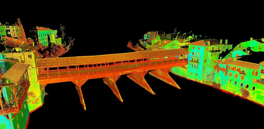
The task of the survey is to carry out a simplification of reality intended to capture and to return, with the best possible accuracy, a strict selection of the geometrical characteristics of the examined object. The traditional geometric survey regards, as critical elements of an entity, the lines of discontinuity (the edges that characterize the surfaces) by recording the geometrical position in a projection plane. This means describing the contour of a building.
The new laser-scanner survey technologies go beyond this selective choice, because the object is no longer represented through a projection in the plane or through three-dimensional predetermined views (axonometries, prospectives), but through a managed three-dimensional model, made of a dense point cloud. For each of these points it is possible to know relations, positions and chromatisms that combined do not define fictitious intersections of planes, but whole surfaces, with good accuracy.
The geometrical surveys must always be integrated with the execution of the material survey, the analysis of the alterations and decays of the surfaces and the survey of the crack pattern. Through careful observation of this pattern, a great deal of information can be collected (such as extension, tilt and crack opening, direction of the relative displacements between the two edges, correspondence between the fissures on the two faces of the masonry, identification of old or recent cracks, such as stable or active ones). This information, integrated with the data of the survey of the structural deformations, is essential to understand the structural effects of the current or past loads applied to the building. A careful analysis of the failures, made by matching the information from the crack observation and those based upon the survey of the structural deformations, allows the following surveys to be carried out and the design of the structural monitoring system to be set up.
